| Home | Specifications | Modifications | Pictures | Trips | Logbook | Links |
 Tuscan archipelago |
 |
| Click on a picture to get it magnified |
Elba Island
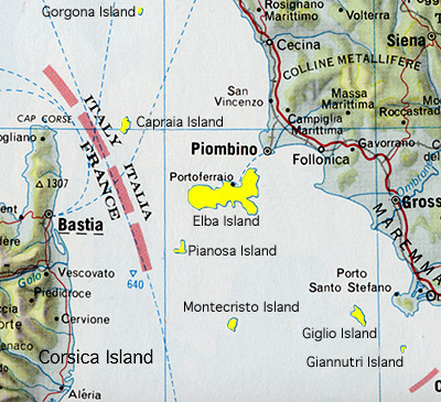
 Map |
 Portoferraio N Elba island |
|
|
|
 Portoferraio, the ESAOM shipyard |
 Portoferraio N Elba island |
 Lacona S Elba Island |
|
|
|
 Cavoli S Elba Island |
 Fetovaia S Elba Island |
 Marciana alta |
 Marciana alta |
|
 Marciana Marina N Elba Island |
 Marciana Marina N Elba Island |
 Procchio, Biodola, Enfola N Elba Island |
 Rio Marina E Elba Island |
 Porto Azzurro S Elba Island |
|||
Elba
is the biggest of the islands of the Tuscan archipelago. On Elba there
are only about 25'000 residents but in the summer months there is a
huge tourism affluence. Portoferraio (N) is the biggest place. Other
villages at the sea are Cavo (NE), Rio Marina (E), Porto Azzurro (E),
Lacona (S), Marina di Campo (S), Cavoli (S), Seccheto (S), Fetovaia
(S), Pomonte (W), Chiessi (W), St. Andrea (NW), Marciana Marina (N)
and Procchio (N). Main Harbors and Marinas are in Portoferraio, Porto
Azzurro and Marciana Marina. There are also a lot of beautiful bays
with good anchoring grounds. ESAOM CESA,
a good shipyard is located in Portoferraio (e-mail). |
|||||


Giglio Island
 Map |
 Giglio Castello Giglio Island |
|
 Campese bay N Giglio Island |
 sundown at the Campese bay N Giglio Island |
 sundown at the Campese bay N Giglio Island |
 Giglio N side |
 the harbor E Giglio Island |
Giglio
is the second biggest island of the Tuscan archipelago. There are 3
villages on Giglio: Giglio Porto on the East side, Giglio Campese in
the North and Giglio Castello on the hill. A small harbor is at Giglio
Porto, hopeless full in the summer months. Good anchoring grounds in the Campese bay, protected from southerly winds, and at two bays adjacent to the harbor. Good ground, if the weather permits it, at Cala dell'allume in the Northwest of the island. |
|||

Giannutri Island
 Map |
 Giannutri Island |
|
 Giannutri Island |
Giannutri
is the island most in the South of the Tuscan archipelago. It's formed like a horseshoe. Giannutri is a private island. There is a small bungalow village on it. The big bay in the middle is a good anchoring site with winds from W to E. Anchoring depth about 20-30 meters even next to the coast. The rest of the island is under natural protection and off limits between 1 nautical mile. |

Montecristo Island
 Map |
 Montecristo Island |
|
That's
the island of the Montecristo count in the novel of Alexandre Dumas.
In the Middle Ages a hiding place for pirates. A lot of people searched for the treasure described in the novel but never found it. Montecristo is since many years under natural protection and the waters around Montecristo are off limits for 3 nautical miles. |

Africa rock
 Africa rock looking W |
 Africa rock looking E |
Africa rock is literally a rock surmounted by a lighthouse. Anchoring is only at very calm weather conditions possible. Shallow waters. Very interesting ground for snorkeling and diving. In the past abounding in fish. |
Pianosa Island
 Map |
 Pianosa Island 1972 |
 Pianosa Island east side |
 Pianosa Island the village |
 Pianosa Island east side |
|
| For about 20 years Pianosa was a high security penitentiary and fully closed to visitors. The waters around Pianosa were off limits between one nautical mile. In 2000 the penitentiary moved away but the island can only be visited with guided tours starting from Elba. The off limits zone of 1 nautical mile still persists. | |||||
Capraia Island
|
|
 Capraia village |
|
|
|
 La Cittadella E Capraia Island |
 The small harbor |
 The small harbor |
 Anchoring site next to the harbor |
 Capraia harbor |
 The village Capraia Island |
 The village Capraia Island |
The
Island of Capraia is of volcanic origins. There is a small harbor on
the East side. In the summer months the harbor is hopeless full. Anchoring
in the bay adjacent to the harbor is OK. Depth 10-15 meters. Sand and
grass. Sometimes in the night, strong falling winds from the South. On the East side there are also a couple of small and not well protected bays for anchoring. The major part of the West side (is not interesting) is under natural protection. The off limits zone is of 1 nautical mile width. |
|||||


Gorgona Island
|
|
Sorry,
no pictures of Gorgona Island. I was never there. On the Gorgona island, there is a penitentiary. Keep at least 1 nautical mile distance from the coast |

Home Specifications Modifications Pictures Trips Logbook Links e-mail